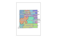
2041. Districts, Waukesha County
2024. Waukesha County. This map displays various political and administrative districts within Waukesha County. Sources vary depending on district type.
2041. Districts, Waukesha County
2024. Waukesha County. This map displays various political and administrative districts within Waukesha County. Sources vary depending on district type.
2042. Diverging Diamond Interchange, WI DOT
2023. Wisconsin Department of Transportation. DDI information was provided and maintained by the Division of Transportation System Development (DTSD) Regional and Bureau staff. This information...
2043. Division of Public Health Regional Offices, Wisconsin 2020
2020. Wisconsin Department of Health Services. This data represents Division of Public Health Regional Office sites for Wisconsin in 2020. [This dataset contains the point locations of the Divis...
2044. DMV Service Center, WI DOT
2022. Wisconsin Department of Transportation. Division of Motor Vehicles Bureau of Field Services operates Customer service centers (CSC) to a place for people to conduct driver license, identi...
2045. DNR & Conservation Commission Lands, Kewaunee County
2024. Kewaunee County. No description provided.
2046. DNR Flood Storage Maps, Waukesha County
2024. Waukesha County. Waukesha County Floodplain and FEMA Data Layers.
2047. DNR Managed Land Parcels Metadata, WI DNR
2022. Wisconsin Department of Natural Resources. Metadata and data dictionary for DNR Managed Land Parcels.
2048. DNR Managed Land Parcels, WI 2022
2022. Wisconsin Department of Natural Resources. This dataset contains Department of Natural Resources (DNR) Managed Lands as parcels with local property name, and GIS and deed acreages in Wiscons...
2049. DNR Managed Land Parcels, WI DNR
2024. Wisconsin Department of Natural Resources. This dataset contains DNR Managed Lands as parcels with local property name, and GIS and deed acreages. Parcels are symbolized as fee simple (DNR...
2050. DNR Managed Land Parcels, Wisconsin 2021
2021. Wisconsin Department of Natural Resources. This data represents WI Department of Natural Resources managed land parcels for Wisconsin in 2021. [The parcels are digitized from deed legal desc...
2051. DNR Managed Land Parcels, Wisconsin 2023
2023. Wisconsin Department of Natural Resources. This data represents DNR managed land parcels in Wisconsin in 2023. [This dataset contains DNR Managed Lands as parcels with local property name, a...
2052. DNR Managed Lands Parcels, WI 2019
2019. Wisconsin Department of Natural Resources. The parcels are digitized from deed legal description and based on the DNR Landnet System (Public Land Survey System, PLSS),Wisconsin Transverse Me...
2053. DNR Managed Lands Parcels, Wisconsin 2020
2020. Wisconsin Department of Natural Resources. This data represents DNR Managed Lands Parcels, Wisconsin in 2020. [The parcels are digitized from deed legal description and based on the DNR Land...
2054. DNR Managed Properties Metadata, WI DNR
2023. Wisconsin Department of Natural Resources. Metadata and data dictionary for DNR Managed Properties.
2055. DNR Managed Properties, WI 2019
2019. Wisconsin Department of Natural Resources. This layer represents the geometry of the real estate holdings of DNR Managed Lands and is not to be interpreted as representing legal property bou...
2056. DNR Managed Properties, WI 2022
2022. Wisconsin Department of Natural Resources. This layer is derived from the Department of Natural Resources (DNR) Managed Lands dataset, dissolved on PROP_CODE. This layer contains fee simple ...
2057. DNR Managed Properties, WI DNR
2025. Wisconsin Department of Natural Resources. This layer is derived from the DNR Managed Lands dataset, dissolved on PROP_CODE. This layer contains fee simple (DNR owned) land, DNR easement on...
2058. DNR Managed Properties, Wisconsin 2020
2020. Wisconsin Department of Natural Resources. This data represents DNR Managed properties, Wisconsin in 2020. [This dataset is derived from the DNR Managed Lands parcel dataset, dissolved on DN...
2059. DNR Managed Properties, Wisconsin 2021
2021. Wisconsin Department of Natural Resources. This data represents WI Department of Natural Resources managed properties for Wisconsin in 2021. [This dataset is derived from the DNR Managed Lan...
2060. DNR Managed Properties, Wisconsin 2023
2023. Wisconsin Department of Natural Resources. This data represents DNR managed lands in Wisconsin in 2023. [This layer is derived from the DNR Managed Lands dataset, dissolved on PROP_CODE. Thi...